For the more active, access to the quarries is possible by walking along this 4.6 km long and low difficulty path, which connects the town with the quarries through the old path where the marble blocks used to go down in carts. by oxen, whose tracks carved into the rock are clearly observable.
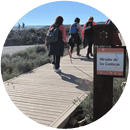
Delve into the heart of the quarries from where the so precious Macael marble is extracted. Along the way we can see how the landscape has been transformed due to the intense exploitation and its contrast with the unexploited areas of the surroundings. From the two viewpoints that we can find on the route, you can enjoy excellent views of the Almanzora Valley and the quarries.
This path runs largely parallel to the “Subida del Mármol” Rally circuit, a mythical event that has been held since the 1950s. It is signposted and approved by the Andalusian Mountaineering Federation. For more information, see the trail map.
Don´t miss it!
Description of the trail
The trail start panel is found leaving the highest part of the town, taking the old AL-840 road that linked Macael with the provincial capital, already on the outskirts of the town, at the first curve that turns to the left.
The itinerary begins to the right of the road, rising a steep but short slope. We continue through a rocky terrain in which we can see marks of the passage of cars, continuing until we find a paved curve that we border on the right without stepping on it to continue until an old plaster that is on our right.
We continue the path while still seeing the road until we reach the old dining rooms. We continue parallel to the road for about 500 meters to reach the Mirador de Cosentino. Parallel to the road, we continue along the path to another viewpoint, Las Canteras, where we finish.
Code: SL-A-170 | Type of trail: Linear | Starting point: Macael | End point: Mirador de las Canteras
Total distance (in meters): 4,600 m. | Estimated walking time: 1 h 33 min.
Accumulated elevation gain: 352 m. | Cumulative descent drop: 37 m.
Difficulty (Assessment according to the MIDE method):
Items of interest
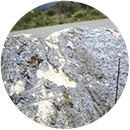
ROAD TRACKS
During the initial part of the route we can walk along the old access road to the quarries, by which the carts loaded with the marble blocks descended. Their footprints are clearly visible on the rocky floor. The carts were pulled by two oxen that were arranged in front and braked in their descent by two other oxen that were arranged behind.
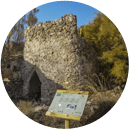
YESERA OF THE PINARICOS
Old plaster from the Moorish period (1489-1568). The Arab culture introduced the widespread use of plaster on the peninsula. Located near a deposit of this mineral, the gypsum was fired in kilns for dehydration and finally ground.
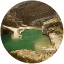
POND
Behind the old dining rooms of the stonemasons, looking to the right we can see a small turquoise blue pool that forms between the marble walls when the water used in the extraction process seeps through.
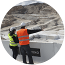
COSENTINO VIEWPOINT
From this viewpoint, built by the Cosentino Group on the quarry that it exploits, it is possible to observe the marble extraction process. To the right it is also possible to see the La Puntilla quarries, the oldest in the area, from which the marble used in the Alhambra Palace in Granada was extracted.
PRESENCE OF OLIGIST
Before reaching the Mirador de las Canteras we can see some large rocks on the road covered with oligisto, a mineral from which iron is extracted.
VIEWPOINT OF THE QUARRIES
From this viewpoint, we will admire the quarries furthest from the urban area such as those of the Pozo, los Azules, Cerro Pelao, or Rambla Orica. It shows spectacular views of the Almanzora Valley and the Sierra de las Estancias.
Do you want to know more about Macael? Call +34 950 128 916 or you can find us at: